
Walpole Complete Streets Project
What are Complete Streets?
"Complete Streets are streets for everyone." SmartGrowthAmerica.org
A Complete Street describes a public right of way that provides safe and accessible options for people of all ages and abilities and all modes of travel, including walking, bicycling, driving, and using public transit. A network of Complete Streets expands travel choices by making it easy for people to cross the road, walk to school, bicycle to work, or hop on and off buses and trains. Complete Streets are designed with all users in mind, and they make non-motorized transportation more convenient, more attractive, and safer.
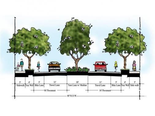
What does a Complete Street look like?
Complete Streets are context sensitive. They have no fixed design because each right of way is different in place and purpose. A Complete Street in an urban area will look very different from a Complete Street in a rural area. What matters is that the elements of each street reflect the needs of the people who use it, regardless of age, ability, or mode of travel.
Complete Streets elements can be realized on a large sale (e.g., intersection improvements) or can be more narrowly focused (e.g., adding a single bicycle lane or crosswalk). The MassDOT Highway Division identifies the following as examples of Complete Streets infrastructure or project types:
• ADA/AAB-accessible curb ramps • Audible pedestrian signals • Bicycle parking facilities • Bus pull-out areas • Curb extensions • Designated bicycle lanes • Detectable warning surfaces • High-visibility crosswalks • Intersection signalization • Medians and pedestrian crossing islands • Pedestrian hybrid beacons • Radar feedback ("Your Speed") signage | • Road diets • Roundabouts • Signal prioritization • Shared lanes and shared-use paths • Street lighting • Street trees and furniture • Traffic calming measures • Transit-only lanes • Transit shelters • Sidewalks • Speed tables and raised crosswalks • Wayfinding signage |
For more information, please visit www.masscompletestreets.com , https://nacto.org/ and https://smartgrowthamerica.org/
Complete Streets in Massachusetts
In 2006, the Massachusetts Highway Department (MassHighway), which was succeeded by the MassDOT Highway Division, became one of the first transportation agencies in the country to clearly realize the need to consider all users – including modes of travel and ability, as well as to consider projects’ context when building and renovating streets, parks, sidewalks, and parking lots statewide. At that time, MassDOT developed its award-winning Project Development & Design Guide.
With the Governor’s Healthy Transportation Policy Directive of 2014 and legislation, the MassDOT together with the MA Department of Public Health, established a funding program to encourage municipalities to routinely include Complete Streets design elements and infrastructure on locally-funded roads. This program consists of three tiers: Tier 1 - Establish a Complete Streets Policy; Once the Policy has been approved by MassDOT, the municipalities develop a community wide Tier 2 – Create a Complete Streets Prioritization Plan; Tier 3 – obtain funding for implementation of the improvements noted in the Tier 2 plan.
Since its launch in July 2018, 206 municipalities have registered to the program, 162 municipal Complete Streets Policies, and a total of 111 Tier 2 plans in the Commonwealth have been approved by MassDOT and 71 Tier 3 funding awards have been made. Since the initiation of the program, funds have been used to construct improvements ranging from new sidewalks and crosswalk rehabilitation to bus stop improvement and installation of bicycle and shared lane markings.
Complete Streets in Walpole
This summer, the Town of Walpole will approve a Complete Streets Policy. This policy, like others throughout the Commonwealth, will disclose that all state, town, and private projects in Walpole take road users of all ages, abilities, and modes of transportation into consideration and set out reasonable definitions of where such consideration might be infeasible. It also sets out design guidance, standards, recommendations, and best practices from both governmental and non-governmental organization to be used by designers for the implementation of the Complete Streets Policy.
Developing Walpole Tier 2 Complete Streets Prioritization Plan
The Town of Walpole was awarded a planning grant from MassDOT to develop a Tier 2 Complete Streets Prioritization Plan and this project has recently begun. This process involves assessing needs such as pedestrian connections, safe pedestrian crossings, safe bicycle routes, among many others. In addition to professional assessment and observation, public input in this process is important and welcomed. As part of the project, an online tool has been set up to allow residents and interested parties to input directly to the project. Anyone who has experienced a problem or has an idea related to street safety and travel options in Walpole is encouraged to access the site http://wikimapping.com/wikimap/Walpole-Complete-Street-.html so that the project team can be aware of these issues as the Plan is developed.